Archaeology: Making the Invisible Visible!
The Angkor Wat ruins, Japanese burial mounds, burnt Roman scrolls... Archaeology's digital revolution is revealing traces of ancient civilizations previously invisible and solving mysteries.
Transcript
The latest technology is reviving sleeping ancient remains.
In the field of archeology, a digital revolution is now underway.
This is the new data for humankind.
This topographic map is LiDAR's creation.
LiDAR is a technology that uses laser reflections to measure the distance of objects and terrain.
It's also a core technology for automated driving.
Ancient remains not discernible by the human eye can be brought to life in three dimensions.
I'm astounded so many historical traces from ancient times to the Middle Ages
remain in good condition under the dense forest.
An amazing god's-eye view!
LiDAR is at work in Japan as well on sacred areas
which up to now have been considered off limits - ancient burial mounds.
The greatest mystery in Japanese history, known as the 'blank 4th century,' is now about to be revealed.
It was totally unexpected to find that many artifacts.
They'd be first-rate historical materials.
And another digital revolution is happening.
Young, AI-driven people are trying to decipher burnt scrolls from the ancient Roman era.
I looked at my phone and there's three Greek letters there!
I did not expect to see that. That was a complete surprise.
So, using new kinds of technology, and that's how we see this revolution in archeology taking place.
Technology visualizes the past that no-one's ever seen before!
Many archaeological sites are located in Siem Reap Province, Cambodia.
Professor Shimoda Ichita of Tsukuba University has long been conducting research in this area.
Whenever I come here, I feel a sense of excitement!
It's like beyond space-time travel, suddenly entering a historical period.
The towering Angkor Wat was built about 900 years ago.
The Hindu-Buddhist temple symbolizes the Angkor dynasty.
The French rediscovered the ruins buried in the jungle in the 19th century.
However, research on it was interrupted by the country's civil war in the 20th century.
It's believed that the dynasty thrived with an advanced civilization in the past, but it remains enigmatic.
Shimoda heads for the temple's rear approach, where there are no tourists.
He goes into the forest that surrounds Angkor Wat.
An essential tool in his survey is a map with LiDAR-based data.
LiDAR says this is the site of a pond,
about 30 meters east to west and 20 meters north to south.
Apparently, an artificial pond was created here, larger than a 25-meter swimming pool.
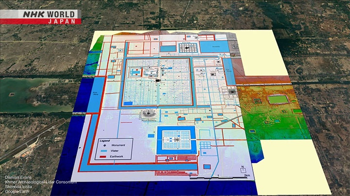
This is a satellite image of Angkor Wat.
On LiDAR's map...
blue indentations indicating the remains of the pond emerge.
LiDAR is the latest technology to apply a laser beam to scan objects.
By measuring the time difference until the light bounces back,
the distance and shape of an object can be precisely measured.
When the data of the light hitting the trees is removed,
the terrain hidden in the jungle stands out in relief.
The first large-scale aerial LiDAR survey in Cambodia was conducted in 2012.
Led by archeologist Damien Evans, researchers from seven countries,
including Japan, France, and the United States, collaborated on the survey.
It revealed a gigantic city larger than Singapore.
They were just spectacular.
The amount of information, the surprises, was just extraordinary.
LiDAR has revealed not only the city's scale...
...but also details of people's lives.
I think this is right in the middle of the pond.
The difference in elevation is less than 2 meters.
Next to the pond is a fill called a 'house mound.'
Traces of daily life, such as rice and cotton, have been excavated from these mounds,
indicating that they are the remains of houses.
Based on the number of ponds and mounds,
it's estimated that about 3,000 people lived within the temple precincts.
Khmer history's been spun from the traces left behind by their rulers,
especially their kings.
The LiDAR data reveals evidence of ordinary people's lives.
LiDAR can also read the meticulously designed urban structure.
When the data of Angkor Thom, the adjacent royal capital, was analyzed...
a grid-like network of waterways emerged in a 3-kilometer square city.
The terrain here is basically flat.
The red area is the perimeter wall.
There was a tunnel under the perimeter wall that took in water.
It's not clear yet, but it appears that the captured water
was somehow drained out of the reservoir in the southwestern corner
by a tunnel to the outside.
A superior water management system, with water circulating on the flat land.
The form of the hydraulic city is now clear.
Based on the latest data, life in those days has come alive.
A rural area gently spread out around the temple.
In this land where the difference between the wet and dry seasons is extreme,
the ancient Khmers lived a comfortable life by managing water well,
producing a rice crop more than once a year.
Thanks to LiDAR, Cambodian archeology has taken a big step forward.
Unfortunately, Dr. Damian Evans, who had been leading the LiDAR survey, fell ill and passed away in 2023.
He had always been very friendly to survey participant Shimoda and generous in sharing information.
In terms of learning the necessary grounding as a researcher...
I was lucky to be able to share even a little time with such a person.
Taking over Dr. Evans' wish, there is something Shimoda wants to clarify.
It's the origin of the water management system.
He believes that the huge network of waterways, covering approximately 1,000 square kilometers,
was not created solely for practical reasons.
The very pragmatic water management facilities
were created to superimpose on the religious cosmology of that time.
Shimoda heads off through the jungle toward Kulen Mountain, 50 kilometers from Angkor Wat.
Known as a sacred mountain, Kulen is the source of all the rivers that flow through the Angkor region.
The rivers do not dry up even in the dry season here,
and over 1,000 symbols of Hindu deities are carved on the riverbed.
The dam built by the ancient Khmers remains just as it has always been.
Guiding Shimoda is Jean-Baptiste Chevance,
who has been conducting research in these mountains for more than 20 years.
The channel that you see here is still the ancient one.
In fact, archeological investigations in this area used to be slow.
Kulen Mountain was a fierce battleground in the civil war from the 1970s.
It became a stronghold of the Pol Pot faction and many mines were buried in the area.
But...
We didn't know until the LiDAR, but now we know they are part of the ancient city of the 9th century.
LiDAR visualized the dam as part of a city built on Kulen Mountain.
If you look closely, faint lines can be seen on the extension of the dam.
The lines overlap with each other in a grid pattern.
The lines were created by the soil being raised.
Dr. Chevance says they were not waterways.
To put it in a broader perspective...
In the midst of the hilly area dotted with, dams, temples, and the royal palace,
straight lines are drawn as if to connect them all.
Moreover, the lines run north, south, east and west exactly.
Based on the LiDAR data, they search for traces of those lines in the jungle.
- I think we've passed it already.
- Passed it?
It's difficult to survey on the ground.
How were the ancient Khmers able to draw such precise lines in this mountainous area?
I think it has a practical meaning for the city, but also probably symbolic.
But the reason remains unknown.
Shimoda's current focus of research is Sambor Prei Kuk, located southeast of Angkor Wat.
His aim is to investigate the remains of a period even older than the Angkor dynasty,
and to get closer to the origin of their ideology.
The Angkor Civilization didn't suddenly emerge out of nothing.
I think there was an ideology based on a strong religious belief.
The latest technology is being used to conduct the survey.
Non-destructive Ground Penetrating Radar, or GPR,
can detect underground structures that cannot be detected by LiDAR.
It can emit electromagnetic waves to capture structures deep underground.
The equipment was purchased during the COVID-19 pandemic.
Now that travel restrictions have been lifted, Shimoda can finally use it to conduct surveys.
His target is the ruins of an as yet unnamed temple located right next to a large dam, code- named M45.
It was dug illegally and nothing but a large hole remains.
By examining the area underground, invisible traces may become visible.
Time for one more place?
- It's 4:55.
- I see.
Maybe I should try one more?
We bought this underground probe
because we want to survey the entire surface of a 2-km square city.
I don't know how long it'll take!
Investigating the underground area of M45 detected a road and other structures.
This is a reconstruction based on the data.
It's conceivable that a road stretched straight east from the central building
and there were large wooden buildings on both sides of it.
Shimoda speculates that this road was an approach leading to the dam.
The water management structure of the dam and the temple are a set.
Not only here, but also for the dam upstream.
This relationship can be seen everywhere.
This will develop into the idea of a unique water-oriented Angkor City.
These traces will eventually help us to identify such a concept.
The temple and the dam were connected by a road.
What was behind that?
The ruins of a temple built in the same period provide a possible clue.
Inside is a 'linga,' a symbol of Shiva, one of the principal deities of Hinduism.
It's the same as those engraved on the riverbed at Kulen Mountain.
You pour water here.
Some of it can go in through the gap.
There's this groove cut at the top, so the water can flow out.
What is poured comes into contact with something sacred
and it turns into a sacred item.
Then it drains out of the temple complex.
This is Shimoda's theory.
Interpreting things broadly, the dam in front of us
and the bank for water management have a similar structure.
Water comes from upstream, and is dammed up,
and like the water that touches a linga,
it turns into something sacred and flows downstream.
Then it is used for agriculture and for daily life.
That's one way of interpreting it.
It's possible to think the temples and the dams were built
as a large-scale integrated structure to transform water into something sacred.
This idea continued to the era of the Angkor dynasty, several centuries later.
And it developed into a huge water-oriented city with temples and reservoirs integrated as one.
The cities of Angkor were designed so that water, the blessing of the gods, would spread throughout them.
It was a bold idea that would be unlikely to appear today.
It was a unique civilization in which an idea or ideology was directly incorporated into city design.
What kind of rich urban spaces should we create in today's society?
To find an answer for that,
it's important to have an idea or ideology to serve as the base.
And LiDAR is also making new discoveries in Japan.
The press heads in droves toward...
I will now show you the current state.
This is the excavation site of a burial mound.
Continuing from last week, I removed the clay
that coated the range from here and inspected the wooden coffin.
This site is about 6 kilometers southwest of the once-mighty Nara Heijo Palace.
Tomio Maruyama Tumulus is located in the corner of a residential area.
In 2022, a treasure that shook the traditional history of Japan was discovered here.
Oh, wow! Looks like a daryukyo,
a daryukyo! Oh, no... What?
This is a 'Daryu-mon' bronze mirror, named after a mythical Chinese creature, daryu.
Both the shape of the shield and its size were the first of its kind in Japan.
In addition... with a curved blade of 2 meters 35 centimeters, the longest in East Asia...
a serpentine sword was also discovered.
The discoveries at this site are yet more of the latest technological achievements made possible by LiDAR.
We conducted an aerial laser survey of the Tomio Maruyama Tumulus.
We found an overhang-like feature on the northeast side of the mound,
may be a structure called a Tsukuridashi.
This is a LiDAR survey map of Tomio Maruyama Tumulus.
It reveals that this tumulus, which had been considered to be a pure round burial mound,
has a protrusion called a Tsukuridashi.
Tsukuridashi is thought to have been a place for holding memorial services
after the burial of a very important person
so many burial accessories have been excavated.
We dug and found something far more amazing than we had imagined,
so we decided to reorganize and continue the investigation this year.
Furthermore, Tomio Maruyama Tumulus is attracting attention
because it was built in what is known as the 'blank 4th century.'
The clues to understanding ancient Japan are Chinese and Korean historical documents.
In the 1st century, there's a description of a gold seal excavated on Shikanoshima Island in Fukuoka Prefecture.
And in the 3rd century, the famous Himiko is mentioned as the queen of the Yamatai Kingdom.
However, no documents describing Japan in the 4th century exist.
It is in the 5th century that Japan next appears on the stage of history
with a description of the Five Kings of the Yamato Kingship.
The 3rd Century is considered to be a period when Japan was ruled by magic.
In the 5th century, the Kingship took on a more armed tone.
The nature of the Yamato Kingship changed in the 4th century,
involving the issues of the Imperial Family and the start of what is now Japan.
How did the country of Japan come into being and extend its dominance?
I'm sorry for being late.
Shibahara is trying to find a key to the blank 4th century in the burial mound.
However, the survey has had its own unique hurdles to overcome.
The Andon-Yama Tumulus is located in Tenri City, Nara Prefecture.
It's believed that it was built in the first half of the 4th century,
and Emperor Sujin, the 10th Emperor of Japan, was buried there.
So, as it's under the jurisdiction of the Imperial Household Agency, this tumulus is inaccessible.
It's the subject of your research, and yet you can't enter!
It's very frustrating.
But if not on the ground, then from the air.
This costs 200,000 dollars.
It's like flying real estate!
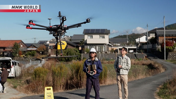
A laser emitted from the machine is diffusely reflected by a mirror
rotating at high speed to collect topographical data.
The survey's carried out by applying the laser diagonally around the mausoleum
without the drone flying directly over it.
You can't fly up there?
No. Permission wasn't granted
because preservation of the tranquility and peace of the mausoleum is involved.
Shibahara has some expectations from the measurement of the tumulus.
Regarding the Andon-Yama Tumulus and the small mounds around it,
there are few cases of such a density.
By comparing those mounds' structures,
we can determine whether the same blueprint was used for all of them
or whether each one was designed differently.
So, are we done here?
The structure of these burial mounds had not been revealed before.
The survey by LiDAR this time has led to another new discovery about the blank 4th century.
This diagram shows the complete shape.
The length of the mound was said to be 242 m originally.
But, the structure seems to end here,
and the length of the mound is actually a little over 230 m.
Did I mention the jinx about the burial mound getting smaller?
If I'm involved in the survey, the length of the tombs shortens!
Furthermore, a comparison with the adjacent mounds led to a hypothesis.
It turned out that the design of the mounds was totally different,
even though they were built at about the same time.
There's been a lot of research on the blueprints of burial mounds,
and it's often said the blueprint of a King's burial mound was distributed,
and smaller copies were built all over the country.
Until now, the prevailing theory was that the Yamato Kingship
had given the blueprints of burial mounds to local regions as a proof of subordination,
since burial mounds with similar structures are scattered all over Japan.
However...
It's harder to find similarities.
This is a survey map of the Andon-Yama Tumulus and the adjacent Kita-Ando-Yama Tumulus.
When adjusted to scale and combined...
The area where this ridge meets the main axis is also out of alignment.
Determination of this line was the
first framework in designing a mound.
The fact that this is off here means
it's not a resizing of a common blueprint
but was different to begin with.
Based on his experiences of surveying not only the Andon-Yama Tumulus but also many other large tombs,
he's come to consider it's unlikely that the blueprints for the King's burial mound were distributed.
In old history textbooks, the expansion of the burial mounds
was described as the expansion of the Yamato Kingship territory,
but in light of the survey results from this time, I feel
the theory that the distribution of the blueprints played a function
in nation-building needs to be re-examined.
So how did the burial mounds spread?
My current opinion is that the Yamato Kingship did not give top-down orders
to the local regions, but rather, the powerful people in each region
wanted to build the same tombs as the King.
Should I say, they wanted to borrow the authority of the Yamato Kingship.
So the ancient burial mounds nationwide may have been voluntarily created by each region.
If my hypothesis is correct,
it would lead to revaluing the nature of the Yamato Kingship.
Rather than saying that they ruled by force?
Anyone who wanted to could join in, like loose club school activities.
Until now, people thought it was like a macho baseball club,
where the first-year students just collect balls!
But it has turned out to be more like an art club,
where those who want to can come to the club room and paint,
and those who don't can come just once in a while.
Art club members will be furious with me!
It's not only archaeological remains that digital technology has made visible.
In March 2023, Nat Friedman, a prominent American IT investor, posted a notice on a social networking site.
"We're using a particle accelerator and AI to read a lost library from a dead empire.
With your help, we'll do it in 2023.
Thrilled to announce the Vesuvius Challenge."
The Vesuvius Challenge is a contest to decipher an ancient Roman scroll written about 2,000 years ago.
The total prize money is $1 million.
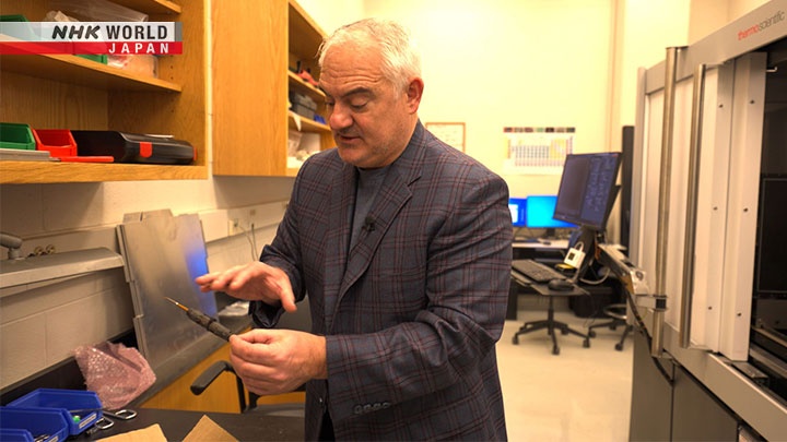
This is Dr. Seales from the University of Kentucky.
His research on computer science was the beginning of the Vesuvius Challenge.
This is modern papyrus, not ancient, but it is real papyrus.
The birth of the burnt scrolls originated in the eruption of Mount Vesuvius in Italy.
The city's archives were swallowed by a pyroclastic flow caused by the eruption.
However, as a result, the scrolls were stored deep underground.
This one is much more fragile because it's been carbonized.
Cannot open this, if you open it, this is what happens.
So those little pieces create a puzzle that's almost impossible to put back together.
The heat from the eruption carbonized the scrolls, and they can't be opened.
But what's incredible is that we can still read this with virtual unwrapping.
It's still possible to read this.
The 'virtual unwrapping' that Seales developed makes the impossible possible.
...to pass the entire sample through X-ray...
First, the scroll is fixed and rotated.
Then, X-rays are applied.
The image of the scroll is captured on this metal plate.
So, before he turns X-rays, we have to close to shield it.
Closed the door.
...and resolution and short exposer time we can see the outline, of both the scrolls,
there's the piece of string that had wrapped the scroll in the center mount post that we used.
We could see them all in real time.
The central mounting stick.
And you can see the scroll spirals out from there.
By scanning it in 3D and converting it to a flat surface,
Seales was able to virtually open a scroll that physically could not be opened.
However, one problem arose.
The challenge of Herculaneum is that the ink doesn't show up very well in the X-ray.
The reason why the ink doesn't show up from Herculaneum very well in X-ray is
because it's made from carbon, which is the same material that the papyrus is made from.
This is the scanned image of the scroll.
The ink made from vegetable charcoals could not be discerned by X-rays.
A lot of people didn't think it would work, but I was not one of those people.
His attention was drawn to a fragment of the scroll that had fallen apart when it was opened.
This allowed the naked eye to confirm the ink.
This is an X-ray scan of the fragment.
When the two were compared, traces of ink could be found.
It was the mark of a subtle change in the material of the papyrus caused by the moisture of the ink.
However, it is almost indistinguishable to the human eye. So...
What the AI dose is, to take signals that are weak like this,
we have a really hard time seeing it and make some prominent, makes it easy to see.
AI is able to find traces of it.
Machines are often good at seeing things that we can't see.
It's possible for them to see with about 70%,
which is a much better percentage than we humans.
But to make that possible, machine learning requires a lot of work.
Only 5 researchers are working on it here,
and we were thinking it would take about 200 years.
Then a wealthy man came up with the Vesuvius Challenge!
Upon hearing of this research, Nat Friedman's initiative led to the Vesuvius Challenge,
a contest to decipher ancient documents, with a prize of $1 million.
Participants detect new flat surfaces using the 3D data provided and use AI to analyze them.
For Seales, however, it meant making all of his research publicly available.
Most researchers do not in open source, most researchers protect their intellectual property,
and we'd been protecting our intellectual property as well
because we have a competitive advantage by doing that.
But what we realized is that Nat was a trusted collaborator,
and that we could do the competition properly if we shared our possession.
And fortunately, what we wanted happen which was we wanted to be able to reward a grand prize, that happened.
From Kentucky, we move west to California.
One of the Vesuvius Challenge 2023 champions lives here.
- Nice to meet you!
- Nice to meet you!
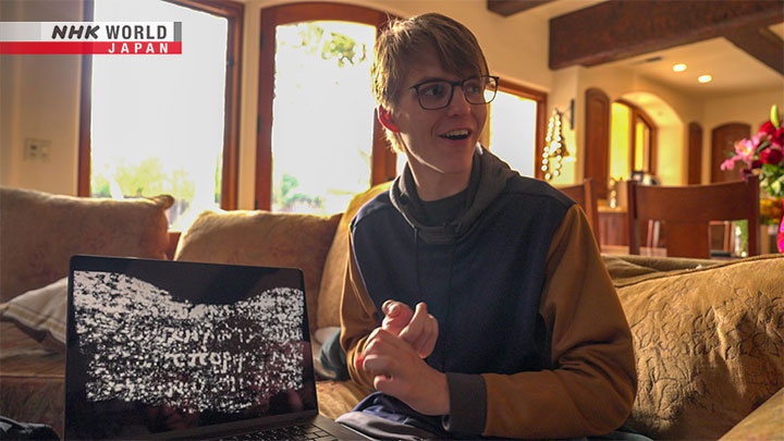
Luke Farritor, 22 years old.
Have you graduated from...?
No, I officially dropped out when I kind of moved out here.
So I was a student back home, but now I'm kind of working for Nat Friedman full time, so...
It's a friend's house... but he'd let me stay here.
Luke was a college student when he learned about the Vesuvius Challenge
after listening to a podcast by the organizer, Nat Friedman.
You know, at first with the competition, people were wondering like, how are we going to find the writing here?
Are we ever gonna find like anything at all, and another contestant named Casey Hanmer,
Casey is, a really, really great guy and he's really smart.
And he was able to actually find some patterns that kind of cracks mud texture, which you see here.
You can see a little bit of it there.
Casey, a participant in the Challenge, found ink marks that had lost water and cracked like dried up soil.
In other words, if you trace the cracked ink, it leads you to finding the letters...
I programmed in AI to find the crack and patterns.
I spent a lot of time just staring at it, finding good examples and stuff. Yeah.
And he started deciphering it using AI.
Six months later...
One day I was at a friend's house at a birthday party.
You know, people are like partying, like you know, playing music and all these things.
And I'm just sitting in the corner not doing anything, because I'm a nerd, right, and, get a text message.
This is like 1 a.m. late at night.
I get a text message from another person on the team.
He said, "Hey, I've just uploaded a new like kind of flattened sheet from the scroll."
So you know, we virtually unwrapped a new piece of the spiral basically.
In no time, Luke took control of his smartphone, accessed his home computer,
and instructed AI to look for "cracks" in a new flat surface.
And then I drive by myself and my drunk friends home.
And then as I'm just walking out of the parking garage to return to my dorm room,
I pull up my phone again to check the results of the ink detection.
And I wasn't expecting to see anything interesting.
But, I look at my phone, and there's three Greek letters there.
I did not expect to see that. That was a complete surprise.
I sent this to my mom, she called she was like, "Luke, this is amazing," you know.
So it was a really, really special moment.
I can actually show you the image.
This way, the ancient letters were deciphered for the first time in about 2,000 years.
That's an O.
This is kind of the Greek letter π.
This is like a reverse P.
These three letters were later found to be part of the word porphyrus, meaning 'purple.'
So the full grand prize is 700,000.
And then I get a third of that because I was a third of the team.
So there were three of us.
Since then, Luke has continued to improve his AI and succeeded in deciphering 5% of the scrolls.
This text had philosophical questions, such as 'Which gives you more pleasure?'
by comparing food that is available in large quantities and food that is available only in small quantities.
So there's a lot of things that we want to keep doing with the scrolls.
So this is 5% of the first scroll.
Now that we have some real data from the competition,
I think we can estimate that we are going to be able to read 85, maybe 90% of the scroll.
- This year?
- This year.
Nowadays, archeology is not only for specialists.
Deep Time is a citizen participation platform
that allows anyone to join in archaeological site surveys from anywhere via the Web.
The mission of the participants is to search for traces of the past on maps.
More than 2,000 archaeological features such as deserted medieval villages and military ranges
have been discovered so far by the general public.
Participants are referred to by a special name: Pastronaut.
Conjunction of two words, the past and astronaut.
Because what we're effectively doing is mobilizing a legion of citizen space archaeologists
to discover new sites using satellite imagery, LiDAR and Earth observation data from the comfort of their own homes.
Pastronauts dive into the world of searching for ruins on the Web.
On the lay of the land, traces of various eras pile up and remain.
By comparing more than ten different types of data obtained from LiDAR and old maps,
they investigate what traces exist and from which era.
It's complex work, like that of an expert, but even amateurs can do it.
There is a unique training program that allows you to have fun while learning.
During the training, the shapes of ruins classified into 13 categories are instilled in your mind.
We have little fun quizzes at the end of every chapter.
For example, can you tell what type of remains this image shows?
The correct answer is a WWI practice trench.
Quizzes are a fun way to deepen your knowledge.
Former tour guide Doug Happer says he's developed a special attachment to the ones he discovered.
I had actually dug at two of them, Dig Ventures did have two digs in that area,
which I use as my starting point.
I almost feel it's my second home.
So the past belongs to everybody.
We want to use technology to broaden what we do involve as many different people as possible.
Let's now return to Japan.
This is Shimane, a place associated with Japan's oldest historical records, the "Kojiki."
Wandering around this mountain are four archaeology enthusiasts.
Where the guys are standing now, there's a stone chamber.
It was dug out in the past and a hole remains.
It's now an empty chamber.
A single slab of stone was used at the back and on both sides.
They were the first people to find this mound.
It's from around the second half of the sixth century.
Last year, using LIDAR survey maps, they discovered a huge number of keyhole-shaped burial mounds.
Amazingly, the total number is...
Seventy-seven.
Previously, we only had five in Okuizumo Town.
This suddenly increased the number.
Too many!
Okuizumo Town made an aerial survey for forest management.
- Did they give you the survey data map?
- Yes, the town provided it.
Originally the town office made a LiDAR survey map to grasp the number and height of trees.
When the team used it to search for burial mounds, they found an unbelievable number, 300,
including 77 keyhole-shaped mounds and small round and square mounds.
We had 153 data maps and went through them very carefully.
- It may hurt your eyes!
- Our eyes were as big as saucers.
What is your relationship?
We're friends who've been interested in ancient mounds since elementary school.
- You were classmates at elementary school?
- Yes.
What's this?
It's a bulletin we made when we were junior high school students.
"Honjo Archeology Laboratory, 1965, No.1."
This article was written by Uchida.
"As long as there are still ancient burial mounds there." It's cool!
As long as there are still undiscovered ancient burial mounds in Izumo...
The enthusiasm of the boys has not abated, and even after reaching 70,
they continue to be fascinated by the ancient mounds.
Could you read the angle?
Mishiro can't see this because of this tree.
- Shall we cut it?
- The angle's too steep.
What kind of society created the burial mounds?
What was life like then?
It would be nice to know something.
The more mounds we find, the more historical research will advance.
Hey, over here!
Today, the four are visiting an expert to improve the efficiency of their mound survey.
Hello, I'm sorry we are late.
Yone Yasumichi is an associate professor at Shimane University.
We've been checking visually to see if the mounds are there or not,
and wondering if we could locate them instantly using AI.
Until now, the mounds have all been found visually.
They wondered if it would be possible to leave this task to AI.
My field of study is forestry.
My research is on identifying tree species using AI.
Research on AI-based identification of various trees, including cypress, pine, and cedar,
has been applied to ancient burial mounds.
We let the AI learn things like the round mounds you found
by enclosing them with something like this.
The result is these colored images.
These circles indicate possible burial mounds found by the AI.
AI found around 4,000 mound-like objects in Okuizumo Town.
It also picked up quite a lot of other stuff.
I want to improve accuracy in the future.
And while they are talking...
- Is that a burial mound?
- Ah, yes!
A new discovery!
It has a narrow part.
It's highly likely. Great!
Now, through the power of digital technology, ancient eras are beginning to tell us a new story.
Opportunities to interact with history are growing, not only for experts but for everyone.
In fact, I've been looking at the map for two weeks, and it's great fun.
So using AI may take away that pastime!
- I'm sure the time you spent looking for the mounds was fun.
- Yes, it was fun, really fun.
- Are you sure you want AI to take away that fun?
- Well, putting that aside...
Being at a good age already, we only have a few years to go!