#36 Wildfires
Wildfires are increasing worldwide and global warming is accelerating the risk. Find out about Japan's unique system for swiftly responding to fires and the latest research on forest fire mitigation.
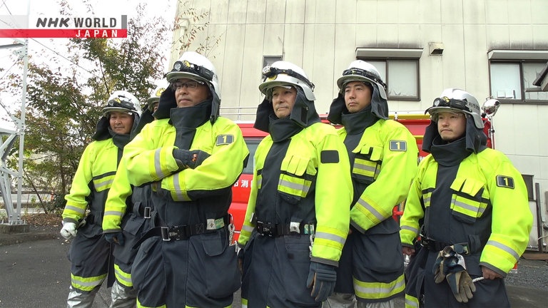
Members of the Shobodan in Ashikaga City, Tochigi Pref. In Japan, aside from full-time firefighters, the Shobodan has been established to put out fires and conduct rescue operations during emergencies.
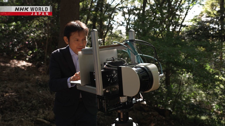
Associate Professor Akira KATO of Chiba University uses lasers to assess the condition of forest trees and investigate the cause of fire.
KATO developed a program to identify the height and curvature of each tree using data obtained by a 3D laser scanner.
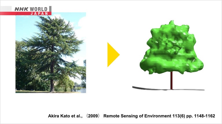
KATO developed a technique known as wrapped surface method to obtain more accurate information on complex tree shapes.
Transcript
Japan has a long history of natural disaster.
Now, power of science is helping to overcome them.
BOSAI: Science that Can Save Your Life
Bright red flames cut through the darkness.
This is the wildfire that scorched the Hawaiian island of Maui in August 2023.
Over 2,200 homes burned to the ground.
The total number of missing people and confirmed deaths exceeded 100.
It was the deadliest wildfire to hit the U.S. in the last 100 years.
In recent years, a series of large-scale wildfires have broken out not only in the United States,
but also in Europe, Australia and other parts of the world.
It is estimated that the area of tree cover that had burnt has doubled in the past 20 years.
The underlying factor in the recent surge is global warming.
There are fears now of a downward spiral, in which global warming increases the risk of forest fires
and in turn, these forest fires accelerate global warming.
Climate change through global warming increases the occurrence of hot, dry and windy conditions that leads to very large fire episodes.
The future projections of climate and fire models suggest that we will continue to see an increase in fire activity
because we'll have increasing occurrence of hot, dry and windy conditions.
Wildfires can burn forests and towns to the ground and even take the lives of people.
How can they be prevented?
Today, we'll introduce Japan's unique system to mitigate fire and the latest technology on fire prevention.
Japan is a land of forests.
Over two thirds of the country's land is covered with forest.
While about 1,000 forest fires occur in Japan annually,
it is uncommon to see large-scale incidents that continue over an extended period, as seen in other countries.
One reason is the abundance of water.
In Japan, where we get lots of rain, forests retain moisture, making it difficult for fires to spread.
There is one other factor that is believed to protect the country from forest fires.
Ahh, the air feels so fresh.
There is a slow flowing river and we're surrounded by mountains.
And, then this town, there is a group of people that protect the place from wildfires.
Let's go and meet them!
Hello.
Hello.
I understand that you
protect the city from fire.
Are you firefighters?
No, we are not.
You're not firefighters?
Are you volunteers?
No, not volunteers.
We're members of "shobodan."
The "shobodan!" So this is the unique system in Japan designed to protect towns from fires.
In Japan, aside from full-time firefighters, "shobodan" has been established.
During emergencies, they rush to the scene to put out fires and conduct rescue operations.
The members are treated as part-time special public servants, and they do get paid, although not substantially.
That is why they are different from volunteers.
In Japan, while there are roughly 167,000 full-time firefighters,
the "shobodan" is almost 5 times that, with approximately 784,000 members.
They play a significant role in preventing forest fires.
Normally, what line of work are you in?
I run a fuel business.
I run a soba restaurant.
I'm a junior high teacher.
I'm a priest at a shrine.
I work for a sheet metal company.
Everyone has completely different jobs.
It must be tough to juggle work
and the "Shobodan."
I work at school and I've had to
leave during class or club activity.
When there's a fire late at night,
I get sleepy the next day.
Sir, you are a Shinto priest.
I can't simply leave during rituals
so I face a dilemma,
as I cannot rush to the fire scene.
It's challenging since I work alone.
Why did you decide to take on
this demanding task?
I love this town
and the people who live here.
I simply want to protect this town.
The members of the "shobodan" juggle their responsibilities to protect their community.
The roots of this practice dates back to the 18th century.
In Edo, the present-day Tokyo, fires frequently caused damage to the city.
This led to the creation of a system where residents took the initiative to protect their own town.
One such example was the firefighting organization known as "Machi-bi-keshi."
The spirit of "Relying on ourselves to protect our community"...this is carried on to this day.
The "shobodan" has proven to be a major source of help in preventing forest fires.
In 2021, a forest fire broke out in this area.
It scorched roughly 167 hectares, which is considered a large-scale fire in Japan.
A total of 331 members of the "shobodan" joined in to put out the fire and stayed on duty throughout the night.
Helicopters cannot operate at night,
so we filled this up with 20 L of water
and tackled the fire directly.
The community's united efforts paid off and the fire was successfully extinguished in 23 days.
While utilizing the power of the "shobodan" to put out fires, research is also being conducted
that focuses on preventing the occurrence of forest fires.
We visited a forest owned by Chiba University that is being used for research purposes.
Hello.
Hello.
I'm Lemi Duncan.
I'm Kato. Nice to meet you.
Nice to meet you, too.
Associate Professor Akira Kato conducts research to help prevent fires by closely analyzing forests.
Can you explain what you're doing?
We're examining how easily fire can spread,
or the risk of forest fires.
The risk of forest fires? What exactly does this mean?
For example, do you think this area
has a high risk or a low risk?
I'm guessing... not so high,
because there's not much around us.
You're correct.
This area is used for research
so it's been cleared and
there's space between the trees.
If a fire starts in such places,
it often dies out naturally.
For instance, if the height of the grass and plants beneath the trees is low, it reduces the risk of fire spreading.
On the other hand, if the vegetation is tall, the fire is likely to move upward,
increasing the risk of spreading over a wider area.
The risk goes up or down
depending on the density or vegetation.
In broad terms, yes.
Kato's research aims to assess the risk of fires based on the density of the forest.
However, there was a challenge of quantifying forests.
Looking at this forest,
you may sense that the trees are spaced apart
or the risk may seem low.
But how does it compare
to other forests?
We needed to quantify it
and obtain data.
Kato is currently testing the use of lasers to take measurements.
The distance is calculated by measuring the time it takes for the laser emitted from the scanner to bounce back from the trees.
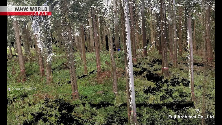
Three-dimensional data is created by measuring 360 degrees.
Using the data, we developed a system
to automatically identify each tree.
This is the image that was created.
It looks just like a photograph.
You can see the position, height, and curvature of each individual tree in detail.
Applying this system, Kato developed a method to assess the risk of forest fires.
I use a computer graphics technique
called "wrapped surface method."
Wrapped surface method?
I've never heard of it.
This is a computer-generated image of trees using the wrapped surface method.
It got its name as the objects look wrapped up.
When a tree is converted into 3D data...
It is represented by dots.
However, in this state, it is difficult to capture the overall shape of the tree.
Here, Kato developed an original technology to determine the precise shape of the tree from the 3D data.
Wrapped surface method captures the complex shape of the tree in a precise and simplified version.
By establishing this method, we can now
accurately identify where the leaves are.
Particularly, where they are
closest to the ground.
Looking at the wrapped surface reconstruction of the tree,
we can see that the distance from the ground is shorter on the left side compared to the right.
This means that the left side is more likely to spread fire, indicating a higher risk.
The ability to accurately identify
the shapes of trees can provide
valuable information about
where fires are more likely to start.
By simplifying the complex shapes of trees, it made it possible to understand their risk of fire.
Aren't they all different types of trees?
The complexity varies depending on the species,
and even within the same kind.
Being able to accurately capture
these differences is interesting.
Furthermore, Kato is now able to automatically calculate the volume using the wrapped surface method.
The volume is equal to the amount of fuel,
so now we know how much space that can be burned.
This method can be used not only
to visually convey the sense of scale,
but also to analyze data quantitatively.
Using data he has obtained, Kato runs computer simulations to predict where fires are likely to occur and how they might spread.
The simulations on the speed of fire spread varies greatly
depending on the accuracy of the data.
Having detailed 3D data helps improve
the accuracy of the simulation.
We can then, for example,
decide on a safe place to evacuate
or where to keep fire extinguishers
even before a fire breaks out.
As global warming continues to advance, the risk of wildfires is increasing around the world.
The hint to reducing this risk may be found here in Japan, "the land of forests."