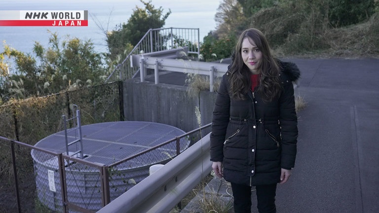
#26 Landslides
In April 2018, a landslide occurred on a hill behind houses in Nakatsu City, Oita Prefecture. The landslide moved sediment over a width of more than 100 meters, completely destroying four houses and killing six people. Landslide hazard areas are found throughout Japan, and the total number of landslide hazard areas is approximately 680,000. Why do landslides occur? Experts believe they are often triggered by heavy rainfall. In this episode, we'll look at the mechanism behind landslides and the latest research on reducing their damage.
Transcript
Japan has a long history of natural disaster.
Now, poser of science is helping to overcome them.
BOSAI: Science that Can Save Your Life.
This video captured the exact moment a landslide occurred in Nara Prefecture.
You can see how the trees are falling down as the slope gives way.
Landslides include all phenomena involving the movement of sediment on slopes, including land slips, debris flows, and rockfalls.
On average, Japan has more than 1,000 landslide disasters every year, many of which cause extensive damage.
In April 2018, a landslide suddenly occurred on the hill behind these houses in Nakatsu City, Oita Prefecture.
Sediment spread over an area more than 100 meters wide, destroying four houses and killing six people.
More than 70% of Japan's land area is mountainous, including volcanic and hilly areas.
Places all over the country are prone to landslides.
In total, there are about 680,000 "Sediment Disaster Risk Areas."
In today's episode, we'll take a closer look at landslides, examine what causes them, and learn how Japan is trying to prevent extensive damage.
Landslides occur all over the world.
In 2009, for example, a huge landslide in Taiwan engulfed an entire village, killing 500 people.
Why do these landslides occur?
Dr. Hirotaka Ochiai of the Japan Forest Technology Association specializes in landslide disasters, and took us to a place where a landslide might occur.
What kind of place is this?
There are many roads running through here.
If a landslide occurs there's a high risk of damage,
so preventative measures have been taken.
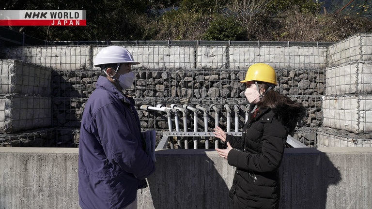
We were taken to a place which is usually inaccessible, to see one of these measures in action.
There are quite a few pipes,
with water coming out of them.
Yes, these are pipes for draining water.
A hole is dug in the slope to
collect water and drain it here.
They're drainage pipes.
Landslides are more likely to occur during heavy rain,
but the biggest cause is groundwater.
Groundwater is everywhere, and it causes landslides.
But how?
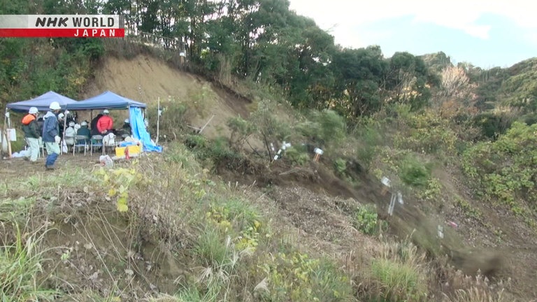
In order to understand the process, in 2018, Ochiai conducted an experiment with the cooperation of Futtsu City, Chiba Prefecture.
He chose this slope for the experiment because it was fragile and there was a high possibility of a landslide occurring.
In the experiment, a fire engine was used to pump water from a 40-ton tank onto the slope.
This simulated the effect of heavy rain, which might trigger a landslide.
Water pressure gauges were placed on the slope to measure the groundwater.
Extensometers were used to measure the movement of the ground surface, and inclinometers were set up to monitor the slope.
20 cameras were installed to capture even the slightest movement of the slope.
We usually do experiments in the lab, but to investigate what happens on a real slope
this kind of experiment is necessary.
The experiment begins.
The watering is equivalent to about 140 mm of rainfall per hour.
This is a level of heavy rainfall that might cause large-scale landslides and overflowing of rivers.
After about 30 minutes.
Water is springing up.
Is it spring water?
It's been a while since we watered the slope, and now water is coming out
at the bottom in several places.
Many mountain slopes in Japan consist of fragile permeable soil on top, and a hard impermeable layer underneath.
When it rains, water steadily accumulates on the hard impermeable layer.
During heavy rain, water soaks into the ground, flows along the impermeable layer and finds a way to the surface.
This is the spring water.
After two hours, Ochiai decided to increase the rainfall to 200 millimeters per hour, which is equivalent to localized heavy rainfall.
10 minutes later the sensor detects a change.
Observational data indicates that the entire slope is beginning to move slightly.
As the amount of rainfall increases, a layer of water develops, and the soil is pushed up.
It moved 35 millimeters in one hour.
A 35 mm movement on a 10 m slope
could cause a landslide to occur.
Upon fast-forwarding the video...
we can see that the ground is starting to shift.
After an hour, the spring water stopped coming out at the bottom of the slope.
Five seconds later...
It's moving!
...a landslide occurred.
Wow, the whole area came down.
The amount of collapsed sediment was estimated to be 100 tons, which moved a distance of more than 20 meters.
What caused the spring water to stop?
The slope was moving little by little,
which temporarily blocked the water's path.
As the drainage path was blocked, the water had no way to escape, and the buoyancy of the groundwater increased greatly.
Ochiai thinks this caused the landslide.
Clearly, rain can cause a buildup of groundwater.
And in fact, most landslide disasters occur during periods of heavy rain, when groundwater increases.
However, we must remain prepared even during periods when there is little rain.
In December 2022, a landslide caused major damage in Yamagata Prefecture.
Heavy snow that had fallen a month earlier melted, leading water to soak into the ground and accumulate in large quantities.
This likely increased the water pressure, triggering the landslide.
As we have seen, the accumulation of groundwater can cause landslides.
But how can we protect ourselves from these sudden landslides?
Various measures are now being taken to try to address this issue.
The pipes we saw earlier were constructed so that groundwater, which causes landslides, can be drained before it accumulates.
Is it common to drain water
using pipes like this?
Yes. They are drilled from the surface,
so they can only drain water in shallow areas.
Since they're easy to construct,
they're the most common way to stop landslides.
This pipe is several meters deep, so that if rainwater accumulates in the ground, it can be drained immediately.
Can this water tell us anything about
where landslides are likely to occur?
The underground bedrock dissolves into the water.
By examining the dissolved components,
we can determine the nature of the landslide, such as whether it will
move slowly or quickly.
There is also a way to drain groundwater that has accumulated deep below the surface.
This is a catchment well.
In some places, the groundwater is deeper,
so a well like this is constructed.
A drainage tunnel is drilled horizontally
from the deep area toward the slope.
Smaller drainage pipes are connected radially to the side wall of the well.
In this way, groundwater is collected from deep underground and drained into the sea or rivers.
When it is difficult to remove groundwater from deep underground, even with drainage pipes and catchment wells, another kind of measure is used.
Water is coming out.
What kind of pipe is this?
It acts like a drainage pipe,
but on a larger scale.
First, a tunnel is dug in the
stable bedrock underground, then drainage holes are drilled from inside the tunnel,
and drainage pipes are inserted.
A tunnel is built in a solid layer below the "slip surface," and groundwater from deep underground is drained through vertical pipes.
This measure is prioritized for places at high risk of landslides, but that risk is quite difficult to determine.
So how do we know which measures will be the most effective for different places?
This is a company that conducts the latest research to improve the accuracy of landslide prevention.
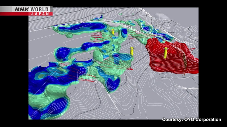
What kind of research are you doing here?
In the past, it wasn't possible to visualize
the amount and location of water underground, but we're developing a way to do so
using 3D geological survey technology.
This is a model showing the area in three dimensions.
The green and blue areas show where groundwater is accumulating, with a lot of groundwater in the blue areas in particular.
And the red area is where it has been confirmed that the slope is moving.
As a preventative measure a catchment well has been built, but the problem is the groundwater that is coming from the surrounding area.
Until now, we didn't know where the groundwater
would come from and how it would accumulate.
This is a visualization of where
the groundwater is likely to be.
Landslides can be prevented by taking measures to drain the surrounding groundwater.
This measuring equipment was used to create the 3D image.
A current is transmitted by this unit, and devices that measure voltage
are placed at various locations.
More than 20 devices were installed on the slope of the mountain to measure the flow of electricity in the ground in three dimensions.
Further research is being done using drones to conduct airborne electromagnetic surveys.
With drone technology,
the resolution is lower, but we can obtain a wider range of information,
and avoid obstacles on the ground.
Here are the results of the analysis.
Groundwater may have accumulated in the blue areas.
By making use of these cutting-edge digital technologies, we can more accurately determine the location and amount of groundwater,
and then deploy the most appropriate measures to prevent landslides.
Measures to prevent landslides continue to evolve.
That being said, it's really important for each one of us to do our part by checking the hazard maps of school routes, places we frequent often, and our neighborhood.
Let's do our best and stay safe.