Phased Array Radar Promises Precise Weather Forecasting
In this episode, a faster and more accurate weather radar system provides instantaneous full 3D images of storm cloud activity 10km up into the sky, promising more precise weather forecasting.
Transcript
Thunderstorms can strike suddenly.
We can't be certain where or when they'll occur.
A torrential rain is pouring down.
Along with thunder.
And with the larger raindrops, hail.
There's flooding in Tateyama City.
The roads in Naha City are flooded.
Weather conditions change moment to moment, evading radar-based predictions.
Minutes later, the storm abates.
Only to appear again elsewhere.
Sometimes, ongoing rain showers over one area will cause enormous flooding.
Other times, a cloudburst is brief, but severe, and highly localized.
There's also a phenomenon known as "training," where a long stretch of storm clouds rolls straight over the same area, like a train.
To minimize storm damage, it's crucial to monitor the cumulonimbus clouds that are the source of such storms.
These clouds can extend more than 10 km into the sky, and require threee-dimensional data to fully grasp.
But, Japan's current weather radar system provides only two-dimensional data,
scanning only the lowest sections of cumulonimbus clouds.
It can provide 3D data, but that takes 5 to 10 minutes to generate.
And the ever-changing clouds are like kids who won't sit still to have their picture taken.
10 minutes is too long for clear, instant images of these clouds, that can develop and move quickly.
Which is why one website has been getting a lot of attention.
This Storm Cloud Navigator site displays storm conditions in nearly real time.
It shows instant 2D and even 3D images of storm clouds 10 km up into the sky, updated every 30 seconds.
It's obviously a lot more detailed data than current radar, which mainly shows activity 1 km above the ground.
The data comes from prototype weather radar on Osaka University's Suita Campus.
The technology is called a "multi-parameter phased array."
It emits a combination of many radio waves in a single beam,
far wider than the beam from a conventional parabolic radar antenna, capturing 3D data in just 30 seconds.
It readily provides fast and precise data about cloud conditions
that can lead to cloudbursts, thunderstorms, training, and even tornadoes.
With the potential to prevent weather events from becoming disasters, this is a huge step forward for weather radar.
It's much higher resolution, in both time and space.
Plus, the data is higher quality.
Overall, its capabilities are second to none.
On today's program, we'll see how this cutting-edge weather radar can provide a sharper picture of the sky above us.
August 2014.
Hiroshima Prefecture experienced record rainfalls, triggering massive mudslides and causing extensive damage.
A long, narrow band of precipitation suddenly formed over the prefecture,
dropping more than 200 mm of rain in some areas in just three hours.
But what exactly caused this?
A lot remains unknown.
But the Japanese archipelago has seen similar torrential rains in linear formations nearly every year since.
These are now widely thought to be caused by something called "training."
That's when cumulonimbus storm clouds roll over an area in a train-like linear formation,
anywhere from 50 to 300 kilometers long and 20 to 50 kilometers wide.
A phenomenon called "back-building" contributes to the formation of these "trains."
In a back-building thunderstorm, a continuing inflow of warm, moist air from over the ocean
is driven by wind and terrain shapes into an updraft of cumulonimbus clouds.
As this process continues, more and more of these clouds form and are carried along the same path,
creating a conveyor belt of cumulonimbus clouds.
This area becomes a "precipitation zone," with ongoing heavy rains.
Recent research suggests that rising seawater temperatures due to climate change are a contributing factor.
As ocean temperatures rise, these "training" events are expected to happen more often...
...raising the risk of floods and landslides.
Another concern is the difficulty of predicting when and where these training events will occur.
These are serious challenges.
The Japan Meteorological Agency began including storm trains in its forecasts in 2022.
If they determine there's a strong chance of a storm train forming,
they'll make an announcement 6 to 12 hours ahead of time, advising people to be on alert.
But with the current technology, storm trains are accurately predicted only one in four times.
Weather forecasts are highly dependent on the radar being used.
The Meteorological Agency has 20 radar stations nationwide.
Here's how the current radar system works...
The radar emits radio waves in pulses.
Those pulses reflect back off of raindrops in the air.
The radar measures the time delay and intensity of those reflections to determine where it's raining and how hard.
But this radar is mainly scanning only the bottoms of the storm clouds.
So, the weather radar images currently provided only show a 2D representation of raindrops closer to the ground.
But the cumulonimbus clouds that cause localized heavy rainstorms can form in just 10 minutes,
and can reach to heights over 10 km.
So, what we could really use is a full 3D picture.
The existing radar system is capable of producing the data for 3D images,
but the additional rotations required of the parabolic antenna take 5 to 10 minutes.
Meanwhile the clouds are constantly changing shape, which makes it impossible to accurately capture a precise still image.
This delays issuing weather alerts, which in turn delays evacuations and other steps to prevent disasters.
But, the new system under development promises to address these issues.
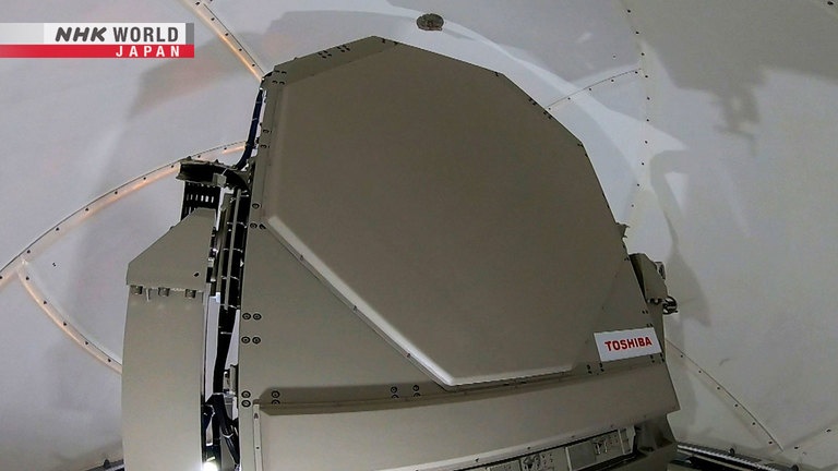
Currently being tested at Osaka University's Suita campus, this is a "Multi-parameter Phased Array Weather Radar" system.
Up on the roof, we get a look at this groundbreaking radar.
Developed by Osaka University in collaboration with the National Institute of Information and Communications Technology,
and others, this is one of only three such radar stations in Japan.
It's a deceptively simple geometric design, around 2 meters by 2 meters.
This emits a wide beam of radio waves into the sky.
Those reflect back off of raindrops.
The array of 112 antennas inside then receives the
reflections and assembles the incoming beam.
Traditional parabolic weather radar completes one rotation to perform a 2D scan.
This mainly looks at the lowest section of the storm clouds.
To capture 3D data, the antenna must complete several rotations, at a different angle each time.
In contrast, a phased array radar emits a single wide beam from an arrangement of 112 electronically steerable antennas.
This makes it possible to capture 3D data in a single rotation.
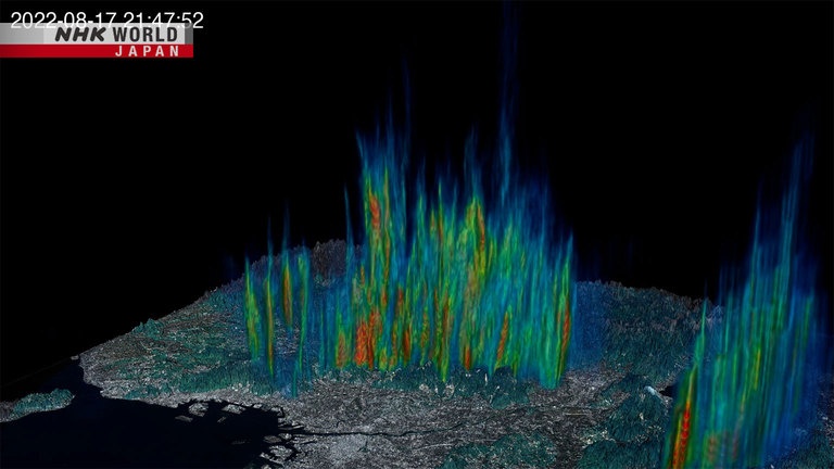
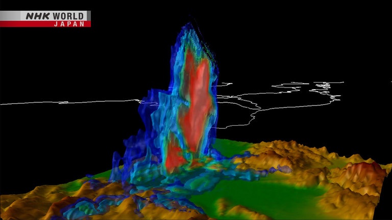
So, what are the advantages of 3D weather images?
This image, captured by the phased array radar, shows cloud conditions up to 15 km in the sky.
The colors, from blue to yellow to red, show the density of raindrops.
So, we can instantly see the intensity of rain happening inside the clouds.
If we play back these 2-per-minute images 450 times faster...
You can see the storm clouds forming
in the sky and then raining down.
These twice-a-minute snapshots allow us
to see the natural cycle of cumulonimbus clouds.
We can watch them take shape, move forward, and then disappear, details previously hard to obtain.
Note the red area inside the clouds.
This is a large cluster of droplets created by updrafts.
It takes about 5 to 10 minutes for these clusters to fall to the ground.
This means it should be possible to predict the onset of heavy rains a few minutes in advance.
Most droplets take shape in this core region
and hit the ground within 10 minutes.
We have to look high up into these clouds
to see this area that causes heavy rain.
So, this radar is excellent for predicting
rainfall in the next 5 to 10 minutes.
The Storm Cloud Navigator web site uses this radar data to stream constantly changing near-real time images of cumulonimbus clouds,
some up to 15 km high, within 80 km of Osaka University's Suita campus.
It provides 3D images for all of Osaka Prefecture and parts of Kyoto, Kobe, and Nara.
The geographic range is limited, but the improvements over conventional weather imaging are striking.
Traditional radar can take 5 or 10 minutes.
In comparison, this radar is 100 times better.
The new radar system is 20 years in the making.
And there were numerous challenges along the way.
One major issue was that using a wider beam resulted in more unwanted reflections off of objects on the ground.
There are some very tall buildings nearby.
Plus, downtown Osaka is right over there.
Lots of skyscrapers.
Reflections off of those buildings can make the
radar detect rain, when we can see there is none.
And they can make a light rain appear heavier.
Those kinds of problems were a challenge.
Professor Ushio and his team resolved this problem
by adjusting the frequencies of the antenna's radio signals to steer the beam away from the ground.
Another major challenge was inaccuracies in the amount of rain measured.
Raindrops, especially bigger ones, tend to flatten out as they fall through the sky, due to air resistance.
Early phased array systems didn't account for this deformation.
This made it impossible to accurately judge the amount droplets in the clouds,
and therefore how much rainfall to expect.
This was solved with "dual-polarization" radar,
which uses radio waves that are polarized to sense in two opposing directions: horizontally and vertically.
Measuring with both polarities at the same time provides a more accurate picture of the droplets,
and thereby the amount of rain to expect.
This phased array radar has better resolution in
both time and space, plus it's also high-precision.
I think it's the best radar in the world.
But before weather stations adopt this new radar system, they'll need to know that it really works.
So, in cooperation with Osaka Prefecture, a pilot study was arranged to test if the system could detect signs of heavy rains.
Phased array radar surveillance of still-forming cumulonimbus clouds
was fed into a computer to see if it could predict cloudbursts and issue warnings in advance.
A large public park was chosen as the location for the first experiment.
The Japan Meteorological Agency defines "heavy rains" as 30-50 mm of rainfall per hour.
When more than 50 mm of rain is expected, they issue alerts in three stages.
Stage 1 is an "advisory" alert, indicating that storm clouds are rapidly forming, but it's not actually raining yet.
Stage 2 is a "watch" alert, when rain has begun to fall and a certain amount is expected.
Stage 3 is a "warning" alert, issued when heavy rains are actually happening.
Statistically, it usually takes around 21 minutes from stage 1 to stage 3.
This allows some time to prepare for coming storms.
These are the results from the park experiment on September 6, 2016.
When the "advisory" alert was issued at 4:09 PM, the park's PA system advised park visitors to seek shelter,
which they then began to do.
The rain came, and intensified, and by 4:21 the heavy rains had exceeded the 50 mm threshold.
Lightning struck, but no injuries were reported.
It seems the advanced alert system worked.
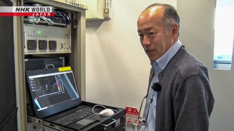
The person who oversaw the experiments had this to say:
This is excellent for wide public spaces like parks
where you can warn people to take prompt action.
Having a heads-up 20 minutes before the rain
starts gives people enough time to seek shelter.
A second experiment was conducted at a stormwater pumping station.
These pumps are sometimes needed during heavy rains to prevent flooding.
If the pumps aren't activated early enough, drainage systems can overflow, flooding roadways.
On this day, the pump station engaged the pumps right after the stage 3 warning alert was issued.
The current standard is still 2D radar that only
shows a limited cross-section of cloud conditions.
But full 3D shows us what the clouds are doing.
There may be rain. It may be torrential.
Participants said this information is helpful
because it lets them think one more step ahead.
These alerts are also crucial for roadway underpasses.
If underpasses aren't closed off before flooding starts, cars could be damaged by the deep water.
It's hard to close off underpasses
like these without reliable information.
It's a major inconvenience for drivers.
And depending on the amount of rain,
the underpasses might not be flooded.
Those points make it a tough decision.
Closing an underpass also means sending someone there to redirect traffic and address problems.
We've found that 20 or 30 minutes isn't
enough lead time to dispatch staff to the site.
This system can reliably predict if it will rain.
But when judging if that rainfall will reach a specific
threshold, it's accurate only 23% of the time.
The experiments with a single phased array radar station helped identify a remaining challenge.
But what if multiple stations were networked together.
Might that fix the problem?
And what would that entail?
Let's use the extremely heavy rainfall in July 2020 as an example.
These torrential rains in the Kyushu and Chubu regions were mainly concentrated in Kumamoto Prefecture.
In Kyushu, the total rainfall in some places exceeded half of the annual average,
causing significant property damage and injuries.
This weather map shows southern Kumamoto Prefecture at that time.
A stationary front produced a continuous inflow of warm, moist air,
creating a lengthy storm train, around 280 km long and 70 km wide.
The record-breaking rainfall went on for quite some time.
The existing weather radar system failed to anticipate this massive storm train.
What if state-of-the-art weather radar had been in use throughout the island of Kyushu at that time?
The RIKEN Center for Computational Science in Kobe is home to the supercomputer Fugaku.
Would this record rainfall have been predicted by a network of phased array radar stations?
This question was put to the world-leading Fugaku, in the form of computer simulations.
The simulations supposed that 17 phased array radar stations were in place, covering all of Kyushu.
The orange circles show the overlapping ranges of the radar stations, shown in red.
Chosen for practicality, these locations are based on existing weather stations and other observatories.
These simulations compared the results with different data sets as input.
The weather forecasting model was given virtual radar data up to 4 AM,
and tasked with predicting what the weather conditions would be one hour later.
The black circles show the Kuma River basin area, which suffered the most damage from the actual storm.
This shows the results with theoretically correct reference data that's considered to closely represent the actual weather at the time.
This shows the results with conventional radar data, updating every 5 minutes.
And this shows the results with phased-array radar data, updating in 3D every 30 seconds.
The researcher who oversaw these simulations had this to say.
With conventional radar data, no storm
clouds appear over the Kuma River basin.
They're to the south, over Tanegashima.
But with the radar data updated
every 30 seconds, the storm location
closely matches that in the reference
data we used for these simulations.
The intensity of the rain matches,
and the amount of rain also matches.
This suggests that a broad network of phased array radar stations
could predict weather conditions up to an hour in advance with considerable accuracy.
This should dramatically improve reproducing
the conditions after it starts raining.
This should make it possible to issue advisories
and warnings earlier than with the current system.
Capable of detecting the signs of an oncoming major storm and accurately predicting its rainfall,
the networking approach holds a lot of promise.
By networking the radar stations together,
the whole is greater than the sum of the parts.
This will alleviate storm-related disasters.
I believe a phased array radar network can do that.
And it's not just for weather.
This new radar could also be used in other ways.
One example is for the growing use of drones...
...and in the future, personal air vehicles.
Detecting, or even controlling
drones and personal air vehicles.
That basic research is already underway.
And this new weather radar could do both,
killing two birds with one stone.
A world-class accurate weather radar system, made in Japan.
A ray of light in preventing the damage caused by excessive rainfall.
A future where we can see everything in the sky might be closer than we think.