If you cannot leave, try to reach higher ground. Go the second floor of your house. But it is important to understand the risks beforehand. Check your local hazard map and identify danger zones near your house and on your commute. Stay updated on the latest evacuation notices and landslide warnings.

Evacuate as soon as there is a landslide warning

Meteorological agencies and prefectural governments issue warnings when they deem the risk of landslides to be great. If you live in a danger area, stay up to date on the latest information and evacuate as soon as possible.
Area mail
Landslide disaster warning information
Announcement from xxx Prefecture xx Metrological District Landslide Disaster Warning Information was issued throughout the city of xx.
App notification
NHK NEWS
xx City: Information on landslide alert
TV alert
Information on disaster prevention
These are signs that a landslide could happen! Evacuate immediately
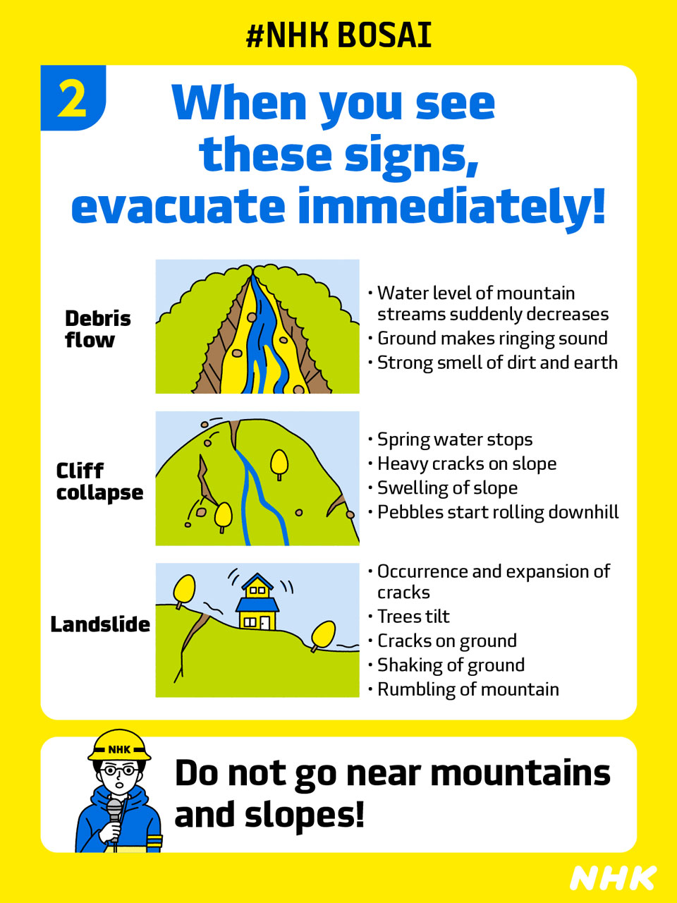
Landslide disasters may occur suddenly, even before an official warning. Watch out for these signs:
- Pebbles roll downhill
- Cracks form
- Water springs from slope
- Water levels decline in nearby rivers
- Rumbling sound from mountain
If you notice these signs or anything else unusual, a landslide is likely imminent. Evacuate areas near cliffs and slopes and protect your safety. Do not approach these areas to confirm any signs of landslides you have seen elsewhere.
Evacuate to second floor as last resort
If it is too dangerous to leave a site, move upstairs as a last resort. Make sure you are in a room that is opposite the side facing a cliff or mountain.

Most importantly, stay up to date on the latest warning information. Know of safe areas beforehand and regularly consult hazard maps. If you live near cliffs, mountains, or mountain streams, consider evacuating when heavy rain is expected.
Hazard maps
During torrential rains in western Japan in 2018, about 90% of places where deaths occurred had been identified in advance as dangerous areas.
Hazard maps are mainly made by local governments and areas where disasters are expected to occur are color-coded.
Search for "(municipality name) hazard map" online. If you cannot find it, contact the municipal government and request it directly. Maps are usually available for floods, tsunamis, storm surges, earthquakes and volcanic eruptions, depending on the area.